- Home
- News
- Magazine story
- Publications
- Dark Matter Energy
- Quantum Computing
- Space Rocks
- Steel Giants
- World Mountaineers
- Andes mountains
- Ayers Rock Australia
- Caspian sea mountains
- Grand Tetons WY
- Himalayan mountains
- Kings peak UT
- Mammoth Mountain CA
- Montgomery Peak CA
- Yosemite
- Mount Elbert CO
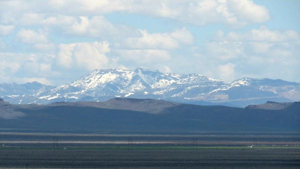
- Mount Grant NV
- Mountains of Africa
- Mount McKinley AK
- Mount Patterson CA
- Mount Rainier WA
- Mount Rose NV
- Mount Shasta CA
- Mount Sill CA
- Mountains of Appalachia
- Mount Whitney CA
- Mount Williamson CA
- Mountains of Alaska
- Mountains of the Alps
- Mountains of Arizona
- Mountains of California
- Mountains of Colorado
- Mountains of Death Valley
- Mountains of Mexico
- Mountains of Montana
- Mountains of Nevada
- Mountains of New Mexico
- Mountains of Oregon
- Mountains of Utah
- Pacific Rim volcanoes
- Rattlesnake Hill NV
- Tohakum Peak NV
- Volcanoes of Washington
- Wheeler Peak NV
- Site map


Mountains of Nevada's Great Basin

Wheeler peak
Boundary peak

Tonopah mining park in Nevada
Haunted mountain mine series.
TripAdvisor photo link.
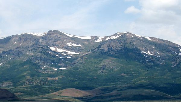
Mount Rose

Tohakum peak


Mount Grant
Arc Dome Nevada

Arc Dome from Middlegate Nevada
View of extreme climb on July 4th at the annual Middlegate mountain races. A flare will be shot when the winner reaches the top.

Arc Dome and Toiyabe Dome
South faces, photo taken from Tonopa, Nevada.
Arc Dome left, Toiyabe Dome right.

Northwest face of Arc Dome
Elevation: 11,781 feet
Coordinates: 38.8324 degrees latitude by -117.3529 degrees longitude
Photo of Arc Dome taken from Drumm Summit on hwy 50 near Middlegate, Nevada.

West face of Arc Dome
The Arc Dome wilderness is a plethora of incredible hiking trails to the top, from its remote base. It takes most of the day to hike to the peak of the mountain hence, most climbers spend the night and hike down the next day.
The view from the forested top of the dome is spectacular where one can see mountains of the Sierra Nevada more than a hundred miles away. Photo of Arc Dome taken from Paradise Summit on hwy 844 NV.

North face telephoto of Arc Dome
Photo of Arc Dome was taken from a point north of Austin, Nevada.

North faces of Toiyabe mountain range
Arc Dome is on the far right in this photo. Follow the link below to learn more about Arc Dome Nevada:

Southwest face of Arc Dome
Photo of Arc Dome taken from hwy 95 just east of Hawthorne, Nevada.
North Toiyabe Range Nevada
West faces of north Toiyabe range
Elevation: 11,233 feet
Photo of Toiyabe Range taken from Sand Springs summit on hwy 50 Nevada.

West face of Bunker Hill Nevada
Photo of Bunker Hill Nevada taken from New Pass on hwy 50 Nevada. Bunker hill is the tallest peak of the north Toiyabe mountain range.
Follow the link below to learn more about the north Toiyabe range Nevada:
East faces of Toiyabe mountain range
Photo of Toiyabe range taken from hwy 50 near Hickson summit.

North faces of Toiyabe Dome and South Toiyabe peak
Photo of mountains taken from hwy 50 about 5 miles east of Austin summit.
Wildcat Peak in Nye county Nevada

North faces of Wildcat peak and Masket peak
Elevation of Wildcat peak: 10,508 feet
Elevation of Masket peak: 10,487 feet
Photo of Wildcat and Masket peaks taken from hwy 50 near Hickson summit.
Follow the link below to learn more about Wildcat peak Nevada:
Www.summitpost.org/wildcat-peak-nv/884922
Follow the link below to learn more about Masket peak Nevada:
Bates mountain and Eagle Butte Nevada
West faces of Eagle Butte and Bates mountain
Elevation of Bates mountain: 8,937 feet
Elevation of Eagle Butte: 8,401
Photo of Eagle Butte and Bates mountain taken from hwy 50 at Austin summit.
Telephoto of Bates mountain and Eagle Butte
Photo taken from Austin summit on hwy 50.
Follow the link below to learn more about Bates mountain Nevada:
Star Peak Nevada

Star Peak Nevada, north face
Elevation: 9,840 feet
Photo of Star Peak taken from Imlay, Nevada.
At over 5,000 feet of prominence, Star Peak provides a plethora of hiking trails to the top. One can even drive a dirt road to within 1,200 feet of the summit. An easy hike for the most part, this mountain can be camped on and different trails discovered every day.
There are no restrictions to climb the peak and it can be reached from hwy 80, about 30 miles north of Lovelock, Nevada.

Star Peak Nevada, south face
Photo of Star Peak taken from Rattlesnake Hill 65 miles away.
Follow the link below to learn more about Star Peak Nevada:
Northeast face of Star peak
Photo of Star peak taken from Cosgrove, Nevada on I80.

South face of Star peak
Photo of Star peak taken from Oreana, Nevada on I80.
King Lear Peak Nevada

South face of King Lear Peak Nevada
Elevation: 8,923 feet
Photo of King Lear Peak and the Jackson mountains taken from Rattlesnake Hill.
King Lear is remote and a very popular climb in spite of its challenging terrain. The view from this popular peak is spectacular, I'm told.
Follow the link below to learn more about King Lear Peak Nevada:

East face of king Lear peak and the Jackson mountains
Photo of King Lear peak taken from Cosgrove, Nevada on I80.
Blue Mountain Nevada
Southeast face of Blue mountain
Elevation: 7,352 feet
A popular cliff climb at almost 3,000 feet in prominence. Also known as Blue Diamond mountain.
Photo of Blue Mountain taken from Cosgrove, Nevada on I80.
Follow the link below to learn more about Blue mountain in Nevada:
Eugene Mountains Nevada

Eugene Mountains Nevada high point, south face
Elevation: 7,582 feet
Photo of Eugene Mountains high point taken from Rattlesnake Hill.
These mountains are a popular climb or the high point can be accessed by 4wd. Gold mining is one of the range's greatest assets and there is a large tungsten mine at the base.
Follow the link below to learn more about the Eugene Mountains Nevada:
Https://www.summitpost.org/eugene-mountains-high-point-nv/894146
Eugene Mountain Range, south face
Photo of the Eugene Mountains taken from Oreana, Nevada on I80.
Sonoma Peak Nevada
West face of Sonoma peak
Photo of Sonoma peak taken from Rose Creek, Nevada on I80.
West by northwest face of Sonoma peak
Photo of Sonoma peak taken four miles north of Winnemucca, Nevada on hwy 95.
Southwest face of Sonoma Peak
Elevation: 9,396 feet
Telephoto of Sonoma Peak taken from about 7 miles north of Fallon, Nevada on hwy 95.
Follow the link below and read the story inspired by Dennis Poulin who climbed Sonoma Peak in 2011.
For anyone traveling through Winnemucca on I80, this mountain regularly catches your attention. The story you read on Summit Post chronicles the journey of a regular traveler passing this mountain, who decided to finally climb it. Enjoy:
Mount Tobin Nevada
South face of Mount Tobin Nevada
Elevation: 9,778 feet
View also includes Fencemaker
peak on the left.
Photo of mountains taken from Sand Springs Summit on hwy 50.

Mount Tobin Nevada, west face
With one of the highest prominences in Nevada of 4,800 feet, Mount Tobin is a respectable climb. An easy climb as well however, getting to the base of the mountain is an adventure into itself.
View includes from left to right, Granite mountain, mount Tobin, and Fencemaker peak.
Photo of mountain taken from Rattlesnake Hill, Nevada.
Follow the link below to learn more about Mount Tobin Nevada:

Northwest face of mount Tobin
View includes China mountain on the left and mount Tobin, right.
Photo of mountains taken from Interstate 80 at Rose Creek, Nevada.
Winnemucca Mountain Nevada
Northeast face of Winnemucca mountain
It may only be 6,742 feet tall but, its close proximity to the north side of I80 and prominence of almost 2,000 feet makes it impressive. Ask anyone who has driven through Winnemucca, Nevada.
Photo of Winnemucca mountain taken from Rose Creek, Nevada.
Follow the link below to learn more about Winnemucca mountain in Nevada:
East face of Winnemucca mountain
Photo of Winnemucca mountain taken four miles north of Winnemucca on hwy 95.
Desatoya Peak Nevada
West by southwest face of Desatoya Peak
Elevation: 9,973 feet
Photo of Desatoya Peak taken from Middlegate Station, Nevada.
Follow the link below to learn more about Desatoya peak Nevada:
Northeast face of Desatoya peak
Photo of Desatoya peak taken from hwy 50 about five miles west of Austin, Nevada.
Northwest face of Desatoya peak
Photo of Desatoya peak taken from hwy 50 about ten miles west of Free Pass.
West face of Desatoya peak over Eastgate, Nevada
Photo of Desatoya peak taken from hwy 50.
West face telephoto of Desatoya peak
Photo of Desatoya peak taken from hwy 50.
Mount Augusta Nevada
Mount Augusta Nevada, east face telephoto
Elevation: 9,966 feet
Mount Augusta is the highest peak in Churchill county Nevada.

Mount Augusta Nevada, east face
Photo of Augusta's east face illustrates its great prominence. There is a rough service road that takes you within 1,300 feet of the summit.
The popular Cherry Valley hunting region is at the far right in this photo.
Much of the climb up this remote mountain is an aggressive hike with only a few steep sections. There are no camping areas and no services of any kind. Climbers should bring enough gear to fix or replace essential things such as tires and hiking equipment.
Avoid driving your 4wd in places where you could get stuck, it is very, very expensive to get a tow in such a remote location.
Mount Augusta Nevada, west face
Photo of Mount Augusta taken from Rattlesnake Hill, Nevada.
Mount August Nevada, south face telephoto
Photo of Mount Augusta taken from Sand Springs Summit on hwy 50.

Mount Augusta Nevada, south face
Follow the link below to learn more about Mount Augusta Nevada:
Northeast face of Mount Augusta
Photo of Mount Augusta taken from hwy 50 about ten miles west of Free Pass.
East by northeast face of Mount Augusta
Photo of Mount Augusta taken from Austin Summit on hwy 50.
Fairview Peak Nevada
East face of Fairview peak
Photo of Fairview peak taken from Middlegate Station Nevada.
North face of Fairview Peak
Elevation: 8,271 feet
Coordinates: 39.2249 degrees latitude by -118.1529 degrees longitude
Photo of Fairview Peak taken from Drumm summit at its base.
Profile, north face, the one to climb
The north face climb up the peak takes you through the old mining town of Fairview but, it looks like somebody was using it for bombing practice, source unconfirmed.
Still the preferred climb to hiking up the service road on the south face.
West face of Fairview Peak
Photo of Fairview Peak taken from Sand Springs summit on hwy 50. Follow the link below to learn more about Fairview Peak Nevada:
Northeast face of Fairview peak
The north slope of Fairview Peak is perfect for the annual mountain bike races at Middlegate, Nevada.
On July 4 every year, mountain bikers will race up the 3,000 foot prominence of this roller coaster mountain to win the most grueling mountain bike race in America.
The peak is only 7 miles from Middlegate Station, base camp where the mountain bike races begin.
Fairview Peak, base camp
Middlegate Station Restaurant and RV park, known for their extraordinary burgers, entertainment, and hospitality.
Please thank them for letting us use their parking lot on July 4th to watch the mountain races.
Prizes will be awarded for all categories.
Races start at 9am, be a Rock Giant tamer.
Ghost town of Fairview Nevada
Somewhere behind the rocks in this photo is the bombed out mining town of Fairview, Nevada. At the foot of Fairview peak, tours to this very remote location are available from Middlegate station.
Www.Destination4x4.com/fairview-churchill-county-nevada-ghost-town/
Sand Springs Range Cairn Nevada

Sand Springs Range NV, northwest faces
Elevation estimated at 7,160 feet for Big Kasock Mountain and 7,450 feet at the Sand Mountain Range's highest point.
Closely guarded by the US Navy, only those with a secret clearance may visit the peaks of this tiny mountain range.
The military radar installations covering the mountain range are critical to Naval air exercises and are off limits to civilians.
Sand Springs Range Cairn, center and highpoint
The Sand Springs Range Cairn is almost directly over project Shoal. The location where a 12 kiloton nuclear bomb was detonated underground in 1963.
Big Kasock Mountain at the south end of Sand Springs Range is the most prominent, appropriately named after a large religious coverall.
Alpite Ridge Nevada at north end of Sand Springs Range
There are no records of any civilians climbing Sand Springs Range, hence there is a high level of curiosity much like area 51 to the south.
Follow the link below to learn more about Sand Springs Range Cairn Nevada:
Https://en.m.wikipedia.org/wiki/Sand_Springs_Range
Big Kasock Mountain Nevada, northwest face
Photo of Big Kasock taken from Rattlesnake Hill. The definition of Kassock is a large religious robe.
Hole in the Mountain Peak, Wells, Nevada
East face of Hole in the Mountain peak
Photo of Hole in the Mountain peak taken from hwy 232 about 10 miles south of Wells, Nevada.
West face of Hole in the Mountain peak
Elevation: 11,311 feet
Photo of Hole in the Mountain peak taken from interstate 80 about 10 miles west of Wells, Nevada.
North face of Chimney Rock
Photo of Chimney Rock taken from Wells, Nevada on Interstate 80.
Ruby Dome range
West face photo taken from Interstate 80 just east of Elko.
Ruby Dome
West face telephoto taken from Interstate 80.
Schell Creek Range in east Nevada
West faces of the Schell Creek range mountains
Elevation: 11,883 feet
Photo of Schell peaks taken from KOA campgrounds just south of Ely, Nevada.
Follow the link below to learn more about the Schell Creek range:

West face of Cleve Creek Baldy in Nevada
Photo of Cleve Creek Baldy taken from Ely Nevada on hwy 50.
South face of Cave Mountain in Nevada
Photo of Cave Mountain taken from hwy 50 about 18 miles south of Ely, Nevada.
East face, Cave mtn., Cleve Creek Baldy, & the Schell mtns.
Photo of four prominent mountains taken from hwy 50 just north of Wheeler peak.
Ward Mountain NV
North face of Ward Mountain
Photo of Ward mountain taken from hwy 50 about 15 miles west of Eureka, Nevada.
North face of Ward Mountain
Telephoto of Ward mountain peak taken from hwy 50 about 15 miles west of Eureka, Nevada.
East face of Ward Mountain, north
Photo of Ward peak, north taken from hwy 50 a few miles south of Ely, Nevada.
Follow the link below to learn more about Ward mountain in Nevada:
East face of Ward Mountain
Photo of Ward peak, north taken from hwy 50 a few miles south of Ely, Nevada.

North face of Mount Grafton in Nevada
On hwy 50 driving south from Ely, mt. Grafton looks like a distant extension of the Ward mountain chain, this photo.

North by northeast face of mount Grafton
Photo taken from hwy 50 below the west face of Wheeler peak.
Follow the link below to learn more about mount Grafton in Nevada: